
Digital Elevation Models
Digital elevation models (DEM) |
How the DEM impacts radiation?
|
Topography impacts solar radiation at ground levels in two ways:
Indeed, according to the atmospheric layer tickness crossed by sun rays when reaching the ground, the radiation is modulated: the higher the elevation of a point, the narrower the atmospheric optical layer, and finally the higher the radiation. Another way to impact the quantity of solar energy received at a given location is the horizon. If a station or installation is located nearby hills or mountains, they can affect the radiation by decreasing the received energy. This is named the shadowing effect due to the "far horizon", to oppose to the "close horizon" due to the trees and buildings which is not available in DEM models. These are the two reasons why two requests inside the same Meteosat pixel does not necessarily return the same radiation values. |
|
Successive DEMs in HelioClim
|
Originally, the DEM named TerrainBase 5' (TB5) was exploited in HelioClim. Available worldwide with an approx. spatial resolution of 10 km (5 seconds of arc), this is the default value stored in HelioClim-1 and HelioClim-3. The spatial resolution of TB5 is smaller than HelioClim-1 (20 km). As a consequence, several Meteosat pixels had the same TB5 value, as depicted on Fig. 1. With the time, DEMs with higher spatial resolution were available; successively BTOPO (1 km), and more recently SRTM (Shuttle Radar Topography Mission). With a spatial resolution of approx. 90 m and an uncertainty of 10 m, this resource is successfully widely used in solar energy. The spatial resolution is smaller than the one of Meteosat, so each pixel exhibits a different SRTM value, as depicted by Fig. 2. In HelioClim-3, SRTM is exploited in two ways:
A webservice of elevation (TB5, GTOPO and SRTM) is available at this link. |
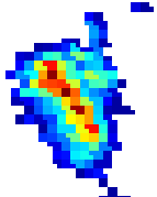 Fig. 1: Corsica - Meteosat pixels with TB5 values |
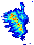 Fig. 2: Corsica - Meteosat pixels with SRTM values |
Other DEMs
ASTER: free, 30 meters. You just have to be register, use the adequate credits, and you are not allowed to resell the data.
IGN: the database BD alti is free for everybody for the spatial resolution 250 m, 500 m, and 1 000 m. Its free use is restricted to public service and Research application. The link to the prices for commercial use is available on the left side of the page.
The product RGE alti is a DEM of 1 meter of spatial resolution, with at least 50 cm of precision. Please find here a summary of the conditions for a free use of all the services of IGN is available.