Introduction
Introduction |
|
Heliosat-4, in three slides - More about McClear - More about APOLLO - Bibliography
|
CAMS (Copernicus Atmosphere Monitoring Service) solar radiation services are composed of two services: CAMS radiation service and CAMS McClear. McClear is one of the major outcome of the CAMS project, which contributes to a detailed assessment of optical variables in the atmosphere (gaz, aerosols, water vapour), clouds and ground albedo. The model exploited in McClear estimates the radiation that should be received if the sky were clear anywhere, since 2004. This model has been created by the Centre O.I.E., the DLR, the Finnish Meteorological Institute), and the European Center for Medium-range Weather Forecasts ECMWF. The method Heliosat-4 processes Meteosat images to create the CAMS radiation service. This method is mainly based on the principle of separability between the clear sky radiation (CAMS McClear), and the effects of clouds (cloud properties from APOLLO, DLR) and ground albedo (derived from MODIS). Please take a look to the description of Heliosat-4 in three slides below. CAMS radiation service covers Europe, Africa, the Mediterranean Basin, the Atlantic Ocean and part of the Indian Ocean (-66° to +66° both in latitude and longitude). CAMS radiation service delivers spectrally-integrated 15 minute Global Horizontal Irradiance (GHI) and Direct Normal Irradiance (DNI) values. |
CAMS radiation service >> |
|
| CAMS McClear >> |
The Heliosat-4 concept, in three slides
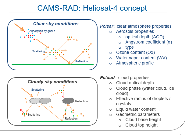
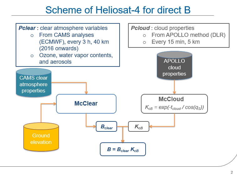
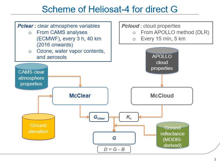
More information about CAMS McClear
CAMS McClear exploits some of the outputs of CAMS-IFS (C-IFS) model, that has been developed by two generations of European projects: MACC and CAMS projects.
C-IFS is based on IFS
CAMS McClear performs a bilinear interpolation of ECMWF ozone, water vapor and aerosol optical depth, whereas it directly exploits MODIS pixel values without any interpolation.
Please note that:
- ground albedo impacts only the diffuse part of the radiation, that is why MODIS-derived ground albedo is only exploited to compute Global component ("G" in the previous slides) of CAMS Radiation service.
- McClear is exploited by HelioClim-3 version 5. As HelioClim-3 stores Global Horizontal Irradiation values from which all other radiation components are derived using a series of models, MODIS ground albedo consequently impacts all components.
McClear exploits several generations of ECMWF atmosphere and ground (albedo) properties:
| CAMS McClear inputs | Spatial resolution | Temporal resolution | For experts only |
| Water vapor, Ozone, and Aerosol Optical Depth |
|
Every 3 hour |
McClear service uses AODs, ozone and water vapor databases from several sources:
|
| Albedo | Approx. 5 km | Every month, climatological (i.e. not updated, but averages) | - |
More information about APOLLO cloud properties (DLR)
Principle
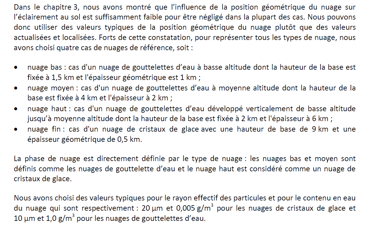
APOLLO uses the multispectral information provided by the SEVIRI instrument of Meteosat Second Generation to derive cloud properties. From this information, DLR created a "mapping" with 4 cases of clouds of reference, associated to an average height and an average geometric thickness. A more precise description of this cloud classification and how it is exploited in Heliosat-4 is available page 88, section 5, of Z. Qu's PhD. Please find below the corresponding extract (in French, Google Trad is my friend :)):
APOLLO and the reliability index
The reliability index is computed with respect to the amount of minutes within the current time slot (15 min or 1 h) without cloud information. In the morning and evening, for very low sun elevation angles, the APOLLO cloud computation gives no results, and this explains the value less than 1 for the first/last 15 min (or 1 h) slot in the morning/evening. During the day, it happens from time to time that the cloud information cannot be computed for a given satellite images set and this also creates a lower reliability index (this can be caused by a problem in the satellite images reception or in the APOLLO computing process). Thus, in summary, the reliability value gives an idea of the amount of interpolated data for the time slot of interest.
For experts: since the release note dated on 2018-06-18, the reliability code is computed as follows:
- Large gaps (1 full day or more) are not filled anymore and correspond to irradiation=NaN.
-
Gaps smaller than 1 day are filled with the following algorithm:
- Apollo cloud data missing in the early morning hours are extrapolated from the first Apollo cloud data available (at sunrise)
- Apollo cloud data missing during a day are interpolated
- Apollo cloud data missing in the evening hours are extrapolated from the last Apollo cloud data available (at sunset).
- Small gaps are notified to end users with reliability=0.
Bibliography Heliosat-4 & CAMS radiation products |
(In alphabetic order and and reverse chronological order)
| Blanc and Wald 2015 | Blanc P., L. Wald, 2015. "L'estimation du rayonnement solaire au sol par la nouvelle méthode Heliosat-4". La Météorologie, 90, 53-61, 2015. | Heliosat-4 |
| Blanc et al. 2014 | Blanc P., Gschwind B., Lefevre M., Wald L., 2014. "Twelve monthly maps of ground albedo parameters derived from MODIS data sets". In Proceedings of IGARSS 2014, held 13-18 July 2014, Quebec, Canada, USBKey, pp. 3270-3272. | MODIS, ground reflectance, albedo |
Content: Presentation of the monthly maps of MODIS parameters (fiso, fvol and fgeo) used to generate albedo for each instant in the year, derived from holy maps of collected MODIS maps (holes due to clouds).
| Gschwind et al. 2019 | Gschwind, B., Wald, L., Blanc, P., Lefèvre, M., Schroedter-Homscheidt, M., Arola, A.: Improving the McClear model estimating the downwelling solar radiation at ground level in cloud-free conditions – McClear-v3. Meteorol Z, 28, 147-163, doi: 10.1127/metz/2019/0946, 2019. | McClear, version 3.1 |
Content: Current version of McClear on Oct. 2019 is 3.1.
| Lefèvre and Wald 2016 |
Lefèvre M. and Wald L., 2016. "Validation of the McClear clear-sky model in desert conditions with three stations in Israel". Advances in Science and Research, 13, 21-26, 2016, doi:10.5194/asr-13-21-2016. |
McClear version 2 |
Content: Article for McClear version 2
| Lefèvre et al. 2013 | Lefèvre M., A. Oumbe, P. Blanc, B. Espinar, B. Gschwind, Z. Qu, L. Wald, M. Schroedter-Homscheidt, C. Hoyer-Klick, A. Arola, A. Benedetti, J. W. Kaiser, and J.-J. Morcrette, 2013. "McClear: a new model estimating downwelling solar radiation at ground level in clear-sky conditions", Atmos. Meas. Tech., 6, 2403-2418, doi:10.5194/amt-6-2403-2013. | McClear |
| Oumbe et al. 2014 | Oumbe A., Z. Qu, P. Blanc, M. Lefèvre, L. Wald, S. Cros, 2014. "Decoupling the effects of clear atmosphere and clouds to simplify calculations of the broadband solar irradiance at ground level". Geoscientific Model Development, 7, 1661-1669, 2014, doi:10.5194/gmd-7-1661-2014. Corrigendum, 7, 2409-2409, 2014. | Decoupling cloudless atmosphere and cloud effects |
| Qu et al. 2016 | Qu, Z., Oumbe, A., Blanc, P., Espinar, B., Gesell, G., Gschwind, B., Klüser, L., Lefèvre, M., Saboret, L., Schroedter-Homscheidt, M., and Wald L., 2016. "Fast radiative transfer parameterisation for assessing the surface solar irradiance: The Heliosat-4 method". Meteorologische Zeitschrift, 26, pp. 33-57, doi:10.1127/metz/2016/0781. | Heliosat-4 |
| Schroedter-Homscheidt et al. 2016 | Schroedter-Homscheidt M., A. Arola, N. Killius, M. Lefèvre, L. Saboret, W. Wandji, L. Wald, E. Wey, 2016. "The Copernicus Atmosphere Monitoring Service (CAMS) Radiation Service in a nutshell", SolarPACES 2016, 11-14 October 2016, Abu Dhabi, UAE. | CAMS-RAD service |
| Tournadre et al. 2018 | Tournadre B., B. Gschwind, C. Thomas, L. Saboret, P. Blanc, 2018. "Characterizing the confidence in a gap-free static atlas of monthly-averaged BRDF parameters derived from MODIS MCD43C1 v5", Poster at EGU General Assembly. | MODIS, ground reflectance, albedo |
| Zhipeng et al. 2012 | Zhipeng Qu, Benoît Gschwind, Mireille Lefevre, Lucien Wald. "Improving satellite-derived estimates of surface solar irradiance using a clear-sky model exploiting recent data sets on aerosol properties". EMS Annual Meeting 2012, Sep 2012, Lodz, Poland. | McClear |
Content: HelioClim-3 version 3 compared to HC3v3-McClear

