Volume of Data
SOLAR IRRADIATION, ULTRAVIOLET AND METEOROLOGICAL VOLUME OF DATA |
PRESENTATIONA volume of data corresponds to long term series of data over a geographic zone. We can provide in HDF5 files:
|
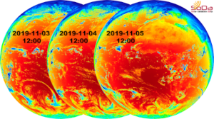
HelioClim-3 Global Irradiation on Horizontal Plane (GHI) at 12 am for 3 consecutive days - Projection Meteosat-11 © Transvalor S.A., Nov. 2019, HelioClim-3v5 |
WHY USING VOLUME OF DATA?
This service is useful for :
- Observe solar resource trends at region and country scales
- Identify potential sites for the development of renewable energy power plants (PV, CSP and wind)
- Analyse solar and meteorological variables over region and territories for your development and research activities in such domains:
- Agriculture and forest ecosystems (solar radiation, meteo and PAR data);
- Health (Ultraviolet data);
- Renewable energy development and electricity stockage studies;
- Meteorological risks studies;
- Pollution studies.
detailed volume of data services
HelioClim-3 solar radiation | McClear clear-sky solar radiation over the world | ||
Irradiation time-series are available from February 2004 up to today with a time step of irradiation data between 1 min and 1 day. Available solar components are:
Unit is Wh/m². | This service delivers radiation values at clear-sky conditions (without clouds) of:
Irradiation time-series are available from February 2004 onwards with a time step between 1 min and 1 day. The spatial coverage is worldwide. | ||
Ultraviolet radiation | Weather from MERRA-2 over the world | ||
Ultraviolet radiation volume of data is built exploiting Wald (2012) method. This method exploits HelioClim-1 Global Horizontal Irradiation monthly values from 1985 to 2005. The same method is applied on HelioClim-3 GHI to estimate UV values with a time step that ranges from 1 min to 1 month from February 2004 onwards. UV components available over the Meteosat-11 satellite coverage are :
Unit is Wh/m². | MERRA-2 database is used to build volume of data of these meteorological components:
For more accurate temperature data, we increase the spatial resolution with altitude parameters from SRTM. The spatial coverage is worldwide. The time step of the data is between 15 min and 1 month. | ||
Do not hesitate to contact us for more information and for a quotation.

