HC3 versions
Helioclim-3 versions |
|
HelioClim-3 version 5 (HC3v5)
HC3v5 exploits the radiation values from the CAMS McClear service (ECMWF) which combined different sources in inputs such as aerosols, water vapor, ozone... to create a better representation of the atmosphere with the time in clear sky conditions. The McClear values are available with a delay of d-1.
McClear has been upgraded to version 3 during the release on 11 Oct. 2017.
Important dates / Improvements
Nov. 2014: installation of version 5 at Transvalor (http://pro.soda-is.com). As McClear computations are very time consuming, Transvalor invested in a SSD disk to speed up the accesses.
HelioClim-3 version 4
HC3v4 exploits a climatologic database based on the turbidity Linke factor to compute the clear sky values (ESRA) (original grid of approx. 50 km, one value per month temporally interpolated to get one value per day over 1 year).
Important dates / Improvements
Oct. 2014: minor modifications in the DNI computation => enhancement of the shape early and late hours of the day. For other PV systems, the change is minor.
Apr. 2013: version 4 becomes our operational version.
In version 3, a Look Up Table (LUT) was used to slightly decrease the radiation values ("bias correction") in the following conditions:
- in desertic areas
- in the middle of the day
- in cloudy weather
... to better fit the ground station measurements. This LUT also increased the high radiation values.
However, MINES ParisTech observed that the application of this LUT was not suitable, in particular because ALL the low radiation values were affected and decreased by the LUT. The effect was particularly visible in winter periods, and in the northern countries of Europe where the values were really too low.
(NB: Another improvement is a better application of the correction in altitude, where is v3 the radiation values were strongly overestimated for high elevation values)
Testimonies: the companies Soligest (France) and ATV (Belgium) confirmed that this version is an improvement compared to version 3.
HC3v3 - Not available anymore due to improvements
So far, the method to compute the diffuse component over the horizontal plane from the Global Horizontal component was Erbs, Klein and Duffie 1982. It switched to Ruiz-Arias 2009 in Jan. 2011, which resulted in an increment in the HelioClim-3 versions.
The second improvement was the correction of local erroneous very high values (spikes).
HC3v2 - Not available anymore due to improvements
The major improvements to create this new version was the modulation of the radiation values using the actual altitude at the exact location of the user's request. The principle is that the higher the elevation, the smaller the thickness of the atmosphere, and the higher the radiation values.
Reference: Wahab, Lel-Metwally, Hassan, Lefèvre, Oumbe and Wald, 2009
From HC2 to HC3
|
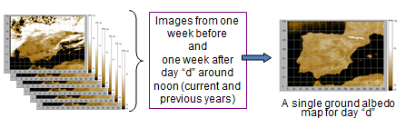
The "Kc_max correction" initiated the new branch of development HelioClim-3. This correction aims at compensating the non-Lambertian properties of the ground surface. The principle of the Heliosat-2 method used to update the HelioClim database is to estimate the "quantity of white" measured in the Meteosat pixels. In that purpose, we need to know the color of the ground (albedo) when the weather is clear. This illustration depicts the hypothesis of computation of the albedo: the ground is seen at least once (minimum value of the pixels) in the past week or at least once in the 15 days surrouding the current day for the previous years. The results of this process is one image of albedo per day, which implies a Lambertian properties of the surface. |
Fig. 1: Hypothesis to compute the albeo in HelioClim => However, this hypothesis was not fully true, since the "color" of the ground depends on the hour of the day. The "Kc_max correction" was originally set to simulate one map per Meteosat slot in the day to take into account shadows. |