
Free Maps
FREE MAPS |
Available for immediate download
- Shapefiles
- Download free GADM world's administrative boundaries for use in GIS and similar software. Administrative areas in this database are countries and lower level subdivisions.
- Download the last QGIS version (current is QGIS "Las Palmas" 2.18.0, released on 2016-10-21)
| Country | Download | Framework | More Info | Last update | ||
|---|---|---|---|---|---|---|
|
Africa
|
CAMS radiation service and CAMS McClear maps. |
|
- | April 2021 | ||
| Algeria |
|
 |
 |
Oct. 2015 | ||
| Egypt |
|
|
|
Oct. 2015 | ||
|
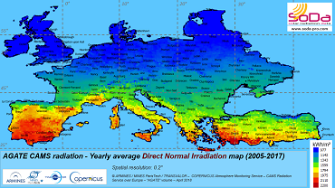
Europe
|
CAMS radiation service and CAMS McClear maps. |
|
- | April 2021 | ||
| France (+Corsica) |
|
ARMINES / MINES ParisTech / Transvalor - www.SoDa-pro.com - Jan. 2015 |
|
Jan. 2017 | ||
| Lybia |
|
|
|
Dec. 2015 | ||
| Mauritania |
|
|
|
Oct. 2015 | ||
| "Middle East": Jordan, Israel, Lebanon, and Palestine National Authority |
|
|
|
Dec. 2015 | ||
|
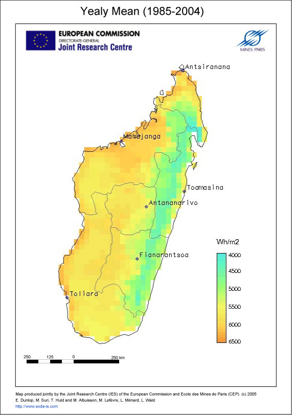
Madagascar
|
Yearly average of daily sums of global horizontal irradiation in kWh/m², averaged on the period (1985-2004). From satellite imagery, HelioClim-1 database. Download the jpeg monthly averages maps for March, June, September, and December. | copyright European Commission - Mines ParisTech / Armines 2005. | 2009 | |||
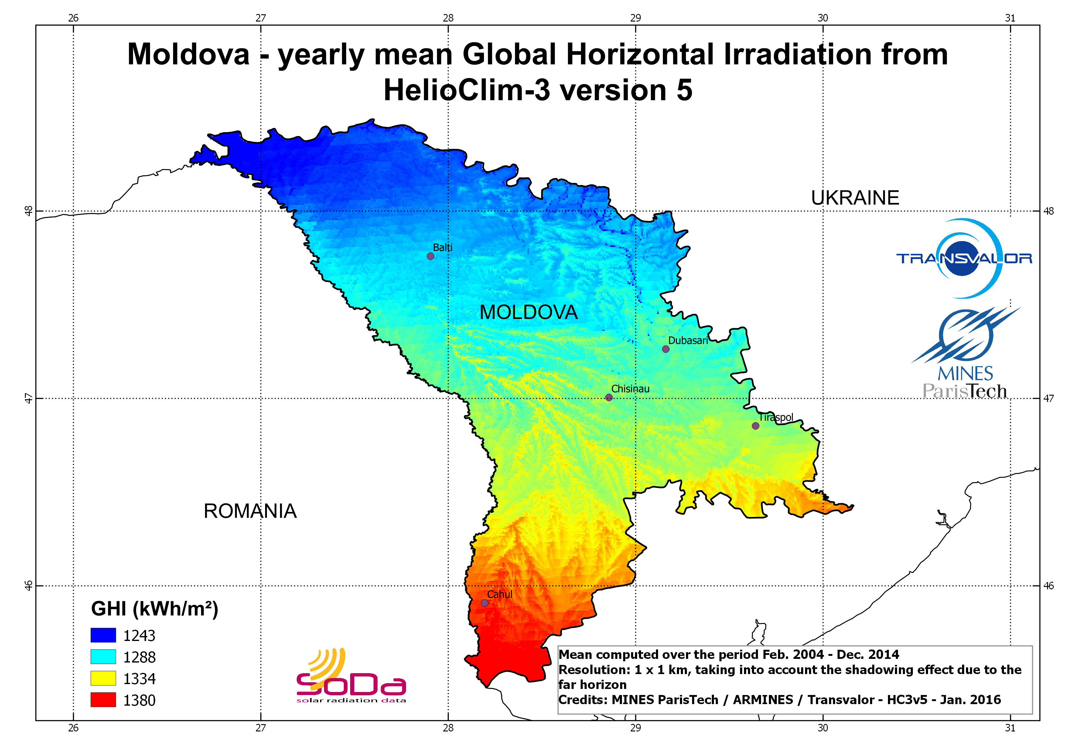
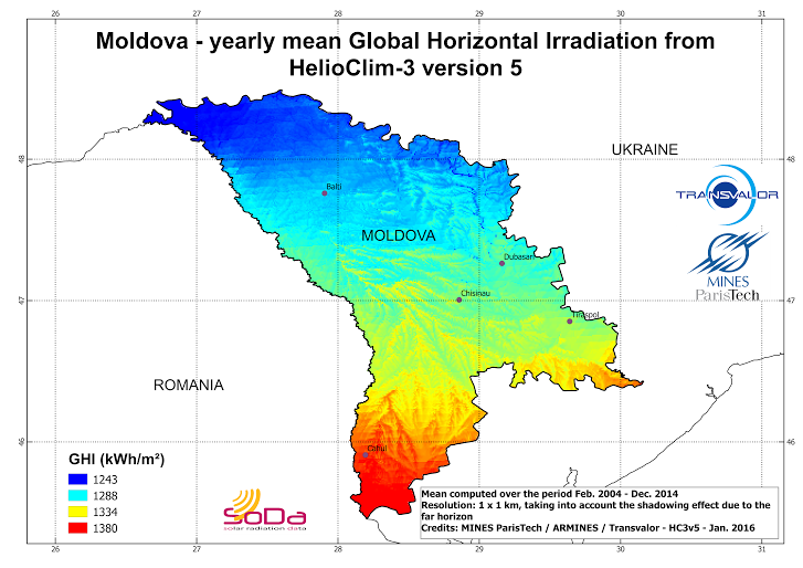
| Moldova |
|
ARMINES / MINES ParisTech / Transvalor - www.soda-pro.com - Jan. 2016 |
|
Jan. 2016 | ||
| Morocco |
|
|
|
Oct. 2015 | ||
| Namibia | ARMINES / MINES ParisTech / Transvalor - www.SoDa-pro.com - Jan. 2015 |
|
Jan. 2015 | |||
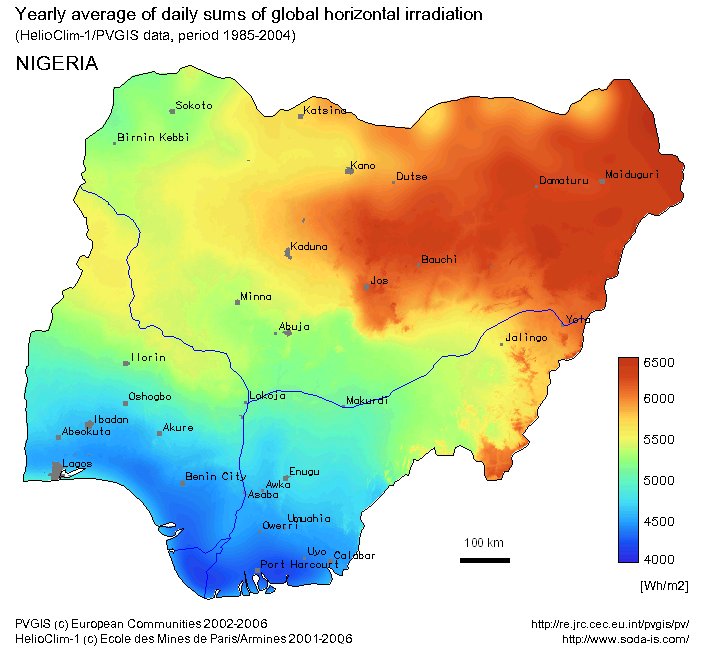
| Nigeria |
|
PVGIS copyright European Commission 2002-2006 and HelioClim-1 copyright Mines ParisTech / Armines 2001-2006. | - | Nov. 2016 | ||
| South Africa |
ZAF_adm0.zip southafrica_MSG_centers.zip mask-south-africa.zip |
ARMINES / MINES ParisTech / Transvalor - www.SoDa-pro.com - Jan. 2015 |
|
Jan. 2015 | ||
| Syria |
|
|
|
Dec. 2015 | ||
| Tunisia |
|
|
|
Oct. 2015 | ||
| Turkey |
|
|
|
Jan. 2016 | ||
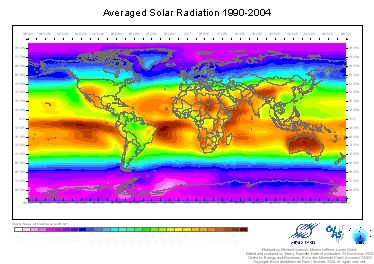
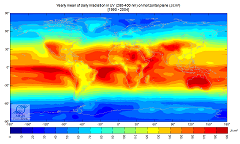
| WORLD |
|
ARMINES / MINES ParisTech - www.soda-pro.com - 2006 | - | Nov. 2016 | ||
|
ARMINES / MINES ParisTech - www.soda-pro.com - 2006 | - | Nov. 2016 | |||
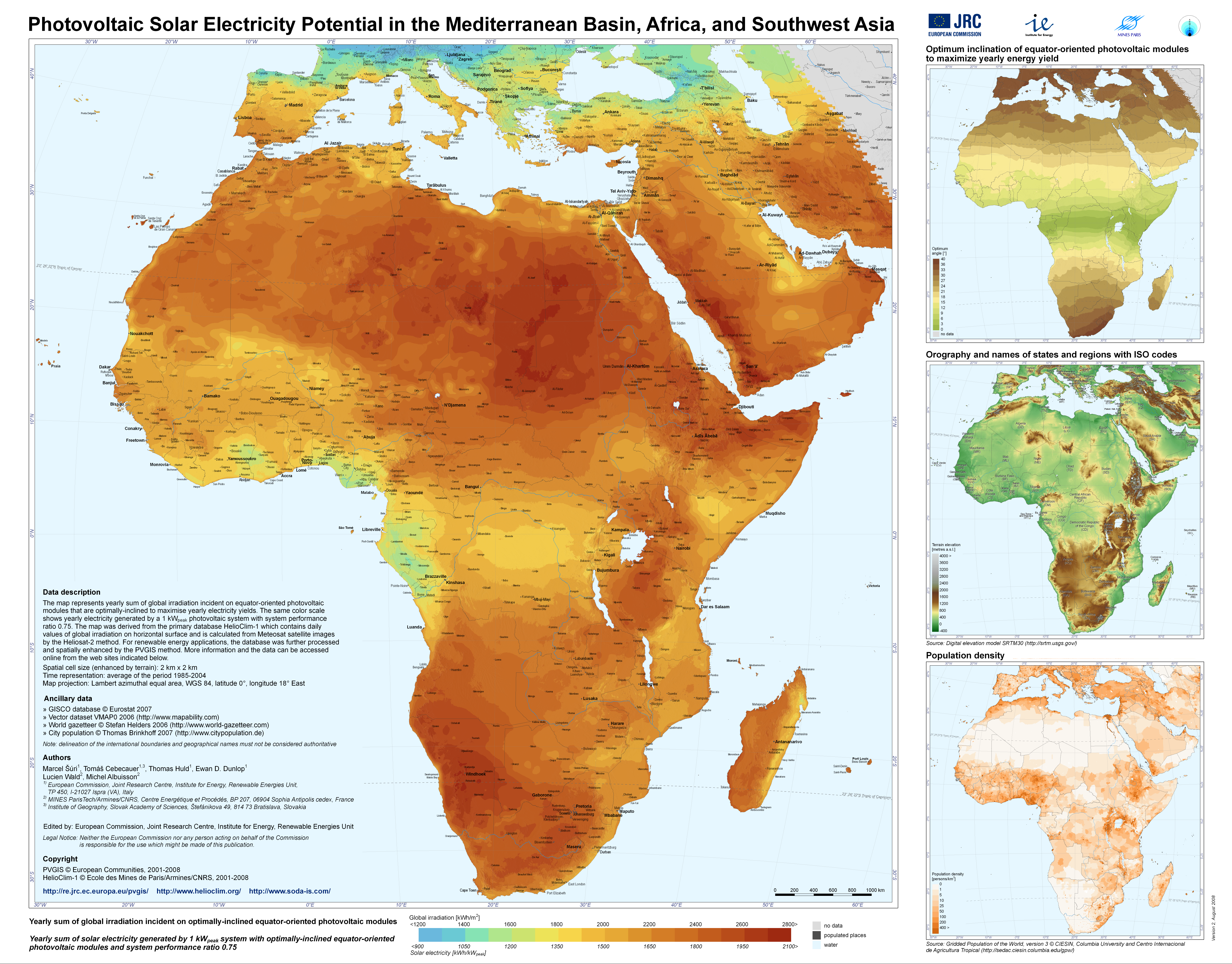
| AFRICA |
|
PVGIS copyright European Commission 2001-2008 and HelioClim-1 copyright Mines ParisTech / Armines 2001-2008. | - | Nov. 2016 |

|
|
More information |
Different ![]() Qgis projects were generated to fulfill the requirements of the SolarMedAtlas project. Please find below the description of the layers available in each Qgis projects.
Qgis projects were generated to fulfill the requirements of the SolarMedAtlas project. Please find below the description of the layers available in each Qgis projects.
Algeria
- Algeria_rivers
- Algeria_electric_lines_diva (not very reliable)
- Algeria_electric_lines_osm (reliable)
- Algeria_electric_lines_Transvalor (reliable)
- Algeria_substations (Osm completed by Transvalor)
- Algeria_cities
- Algeria_lakes
- Algeria_borders
- Algeria_BNI: yearly averaged HelioClim-3 version 5 Direct Normal Irradiation map at 1km, taking into account the shadowing effect of the far horizon (SRTM). Projection: WGS84. coordinates of the upper left corner (-8.68°, 37.09°), spatial step: 0.0083° corresponding to approx. 1km, number of longitudes: 2479, number of latitudes: 2175. Image tiff in uint16, missing value: 65535
- Algeria_GHI: idem Global Horizontal Irradiation
- Algeria_SRTM: same bounding box as the radiation raster layers
- Algeria_globcover: land description
Egypt
- Egypt_rivers
- Egypt_electric_lines (credits: Osm, Diva and Transvalor)
- Egypt_substations (Osm completed by Transvalor)
- Egypt_cities
- Egypt_lakes
- Egypt_borders
- Egypt_BNI_horizon1: yearly averaged HelioClim-3 version 5 Direct Normal Irradiation map at 1km, taking into account the shadowing effect of the far horizon (SRTM). Projection: WGS84. coordinates of the upper left corner (-24.69°, 31.66°), spatial step: 0.0083° corresponding to approx. 1km, number of longitudes: 1466, number of latitudes: 1160. Image tiff in uint16, missing value: 65535.
- Egypt_GHI_horizon1: idem Global Horizontal Irradiation
- Egypt_SRTM: same bounding box as the radiation raster layers
- Egypt_globcover: land description
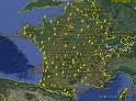
France
- Shapefile of borders
- Localization of the centers of the Meteosat pixels in France
- KMZ file with the locations of the Meteofrance stations measuring the Global Radiation. Download this information also in CSV file.
Lybia
- Lybia_borders
- Lybia_towns
- Lybia_substations_Osm_completedby_Transvalor
- Lybia_lakes
- Lybia_rivers
- Lybia_electric_lines_Diva (corrected by Transvalor, reliable)
- Lybia_electric_lines_Osm (reliable)
- Lybia_electric_lines_Transvalor (reliable)
- Lybia_BNI: yearly averaged HelioClim-3 version 5 Direct Normal Irradiation map at 1km, taking into account the shadowing effect of the far horizon (SRTM). Projection: WGS84. Coordinates of the upper left corner (25.66°, 42.10°), spatial step: 0.0083° corresponding to approx. 1km, number of longitudes: 2298, number of latitudes: 754. Image tiff in uint16, missing value: 65535.
- Lybia_GHI: idem
- Lybia_SRTM: same bounding box as the radiation raster layers
- Lybia_Globcover: land description
- Lybia_slope (computed from SRTM)
Mauritania
- Mauritania_rivers (No lakes in this country)
- Mauritania_electric_lines_Osm (NB: the layer of electric lines from Diva was not relevant on this country)
- Mauritania_substations
- Mauritania_cities
- Mauritania_borders
- Mauritania_BNI_horizon1: yearly averaged HelioClim-3 version 5 Direct Normal Irradiation map at 1km, taking into account the shadowing effect of the far horizon (SRTM). Projection: WGS84. coordinates of the upper left corner (-17.08°, 27.29°), spatial step: 0.0083° corresponding to approx. 1km, number of longitudes: 1471, number of latitudes: 1506. Image tiff in uint16, missing value: 65535.
- Mauritania_GHI_horizon1: idem Global Horizontal Irradiation
- Mauritania_SRTM: same bounding box as the radiation raster layers
- Mauritania_globcover: land description
Middle East: Jordan, Israel, Lebanon, and Palestine National Authority
- MiddleEast_borders
- MiddleEast_cities
- MiddleEast_substations
- MiddleEast_lakes
- MiddleEast_rivers
- MiddleEast_electric_lines_diva (not reliable)
- MiddleEast_electric_lines_osm (reliable)
- MiddleEast_BNI: yearly averaged HelioClim-3 version 5 Direct Normal Irradiation map at 1km, taking into account the shadowing effect of the far horizon (SRTM). Projection: WGS84. Coordinates of the upper left corner (34.20°, 34.69), spatial step: 0.0083° corresponding to approx. 1km, number of longitudes: 611, number of latitudes: 660. Image tiff in uint16, missing value: 0.
- MiddleEast_GHI: idem
- MiddleEast_SRTM: same bounding box as the radiation raster layers
- MiddleEast_Globcover
Moldova
- Moldova_borders
- Romania_borders
- Ukraine_borders
- Moldova_cities
- Moldova_horizon1_HC3v5_GHI_YearAv: yearly map of Global Horizontal Irradiation, averaged over the year Feb. 2004 to Dec. 2014. Spatial resolution 1 km, taking into account the shadowing effect of the far horizon. Projection: WGS84. Coordinates of the upper left corner (26.62°, 48.49°), spatial step: 0.0083° corresponding to approx. 1km, number of longitudes (columns): 425, number of latitudes (lines): 364. Image tiff format Uint16, missing value: 0.
Morocco
- MOROCCO_electric_lines (credits: osm and Transvalor)
- MOROCCO_substations (completed by Transvalor)
- MOROCCO_cities
- MOROCCO_lakes
- MOROCCO_borders
- MOROCCO_BNI_horizon1: yearly average HelioClim-3 version 5 Direct Normal Irradiation map at 1km, taking into account the shadowing effect of the far horizon (SRTM). Projection: WGS84. Coordinates of the upper left corner (-17.11°, 35.92°), spatial step: 0.0083° corresponding to approx. 1km, number of longitudes: 1933, number of latitudes: 1819. Image tiff in uint16, missing value: 65535.
- MOROCCO_GHI_horizon1: idem Global Horizontal Irradiation
- MOROCCO_SRTM: same bounding box as the radiation raster layers
- MOROCCO_globcover: land description
Syria
- Syria_borders
- Syria_substations (completed by Transvalor)
- Syria_lakes
- Syria_rivers
- Syria_electric_lines_osm (reliable)
- Syria_electric_lines_diva (not reliable)
- Syria_BNI: yearly averaged HelioClim-3 version 5 Direct Normal Irradiation map at 1km, taking into account the shadowing effect of the far horizon (SRTM). Projection: WGS84. Coordinates of the upper left corner (35.72°, 37.32°), spatial step: 0.0083° corresponding to approx. 1km, number of longitudes: 799, number of latitudes: 602. Image tiff in uint16, missing value: 0.
- Syria_GHI: idem
- Syria_SRTM: same bounding box as the radiation raster layers
- Syria_Globcover: land description
Tunisia
- Tunisia_borders
- Tunisia_substations (completed by Transvalor)
- Tunisia_lakes
- Tunisia_rivers
- Tunisia_electric_lines_osm
- Tunisia_electric_lines_Transvalor
- Tunisia_BNI: yearly averaged HelioClim-3 version 5 Direct Normal Irradiation map at 1km, taking into account the shadowing effect of the far horizon (SRTM). Projection: WGS84. Coordinates of the upper left corner (7.47°, 37.35°), spatial step: 0.0083° corresponding to approx. 1km, number of longitudes: 490, number of latitudes: 854. Image tiff in uint16, missing value: 65535.
- Tunisia_GHI: idem
- Tunisia_SRTM: same bounding box as the radiation raster layers
- Tunisia_Globcover: land description
NB: both electric lines layers have been checked and are relevant. The one obtained from diva was not reliable enough, so we decided not to provide this layer.
Turkey
- Turkey_borders
- Turkey_cities
- Turkey_substations (completed by Transvalor)
- Turkey_lakes
- Turkey_rivers
- Turkey_electric_lines_diva (not reliable)
- Turkey_electric_lines_osm (reliable)
- Turkey_electric_lines_Transvalor (reliable)
- Turkey_BNI: yearly averaged HelioClim-3 version 5 Direct Normal Irradiation map at 1km, taking into account the shadowing effect of the far horizon (SRTM). Projection: WGS84. Coordinates of the upper left corner (25.66°, 42.10°), spatial step: 0.0083° corresponding to approx. 1km, number of longitudes: 2298, number of latitudes: 754. Image tiff in uint16, missing value: 65535.
- Turkey_GHI: idem
- Turkey_SRTM: same bounding box as the radiation raster layers
- Turkey_Globcover: land description
Europe maps "AGATE" of CAMS radiation data and CAMS McClear
More info on AGATE data - Access to JADE volume (Africa)
| Radiation Component | DOWNLOADS |
|---|---|
|
AGATE GHI Global Horizontal Irradiation |
Download zip-compressed yearly and monthly averaged GHI maps © ARMINES / MINES ParisTech / TRANSVALOR / ECMWF - COPERNICUS Atmosphere Monitoring Service – Monthly and yearly average Global Horizontal Irradiation maps from CAMS Radiation Service over Europe – "AGATE" volume |
|
AGATE DHI Diffuse Horizontal Irradiation |
Download zip-compressed yearly and monthly averaged DHI maps © ARMINES / MINES ParisTech / TRANSVALOR / ECMWF - COPERNICUS Atmosphere Monitoring Service – Monthly and yearly average Global Horizontal Irradiation maps from CAMS Radiation Service over Europe – "AGATE" volume |
|
AGATE Gc Global Horizontal Irradiation in cloud-free conditions |
Download zip-compressed yearly and monthly averaged Gc maps © ARMINES / MINES ParisTech / TRANSVALOR / ECMWF - COPERNICUS Atmosphere Monitoring Service – Monthly and yearly average Global Horizontal Irradiation maps in cloud-free conditions from CAMS McClear over Europe – "AGATE" volume |
|
AGATE BNI Direct Normal Irradiation |
Download zip-compressed yearly and monthly averaged BNI maps © ARMINES / MINES ParisTech / TRANSVALOR / ECMWF - COPERNICUS Atmosphere Monitoring Service – Monthly and yearly average Direct Normal Irradiation maps from CAMS Radiation Service over Europe – "AGATE" volume |
Africa maps "JADE" of CAMS radiation data and CAMS McClear
More info on JADE data - Access to AGATE volume (Europe)
| Radiation Component | DOWNLOAD monthly and yearly maps |
|---|---|
JADE GHI Global Horizontal Irradiation | Download zip-compressed yearly and monthly averaged GHI maps © ARMINES / MINES ParisTech / Vaisala / ECMWF - COPERNICUS Atmosphere Monitoring Service – Monthly and yearly average Global Horizontal Irradiation maps from CAMS Radiation Service over Africa – "JADE" volume |
JADE DHI Diffuse Horizontal Irradiation | Download zip-compressed yearly and monthly averaged DHI maps © ARMINES / MINES ParisTech / Vaisala / ECMWF - COPERNICUS Atmosphere Monitoring Service – Monthly and yearly average Global Horizontal Irradiation maps from CAMS Radiation Service over Africa – "JADE" volume |
JADE Gc Global Horizontal Irradiation in cloud-free conditions | Download zip-compressed yearly and monthly averaged Gc maps © ARMINES / MINES ParisTech / Vaisala / ECMWF - COPERNICUS Atmosphere Monitoring Service – Monthly and yearly average Global Horizontal Irradiation maps in cloud-free conditions from CAMS McClear over Africa – "JADE" volume |
JADE BNI Direct Normal Irradiation | Download zip-compressed yearly and monthly averaged BNI maps © ARMINES / MINES ParisTech / Vaisala / ECMWF - COPERNICUS Atmosphere Monitoring Service – Monthly and yearly average Direct Normal Irradiation maps from CAMS Radiation Service over Africa – "JADE" volume |