
Solar Atlas
SOLAR, ULTRAVIOLET AND METEOROLOGICAL ATLASES | Last update: September 2020 |
An atlas is a set of digital maps available online used to exposed one or many types of data on a specific region.
We provide different type of atlases with the spatial and temporal coverage of your choice from February 2004 onwards.
We can deliver averages data but also yearly and monthly values.
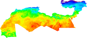
SOLAR ATLASES Solar atlases can include these features:
|
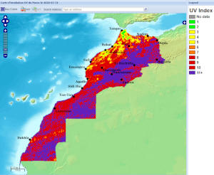
ULTRAVIOLET ATLASES
Ultraviolet Atlases are built using Wald (2012) method. This method exploits HelioClim-1 Global Horizontal Irradiation values to estimate daily, monthly and yearly values of this radiation component from 1985 to 2005.
The same method is applied on HelioClim-3 GHI to estimate UV values with a time step that ranges from 1 min to 1 month from February 2004 onwards.
UV components available are:
- UV-B (280-315 nm)
- UV-A (315-400 nm)
- UV TOTAL (280-400 nm)
- UV ERYTHEMAL
- UV INDEX
METEOROLOGICAL ATLASES
We can deliver meteorological atlases including these components from MERRA-2 database :
Temperature (at 2 m),
- Relative Humidity (at 2 m),
- Pressure (at 2 m),
- Wind speed and direction (at 10 m),
- Rainfall,
- Snowfall,
- Snow depth.
For more accurate data, we increase the spatial resolution with altitude parameters from SRTM.
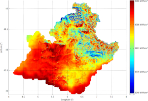
REALIZATIONS
 | 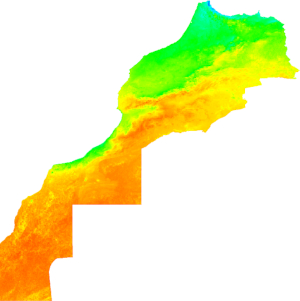 | 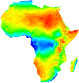 |
|
|
|


 |  | |
|
If you are interested in developping a solar atlas over the region of your choice under Meteosat-11 coverage, please contact us!