
HelioClim-3 overview
Helioclim-3 (HC3) overview |
| HELIOCLIM-3 IDENTITY CARD | |||
|---|---|---|---|
| Type of ressource | Online solar radiation satellite-derived database | ||
| Access | Via the SoDa website (for pay) / automatic ( for pay) | ||
| Provider | MINES ParisTech / ARMINES / VAISALA | ||
| Outputs | All radiation components over a horizontal, fix-tilted, and normal plane | ||
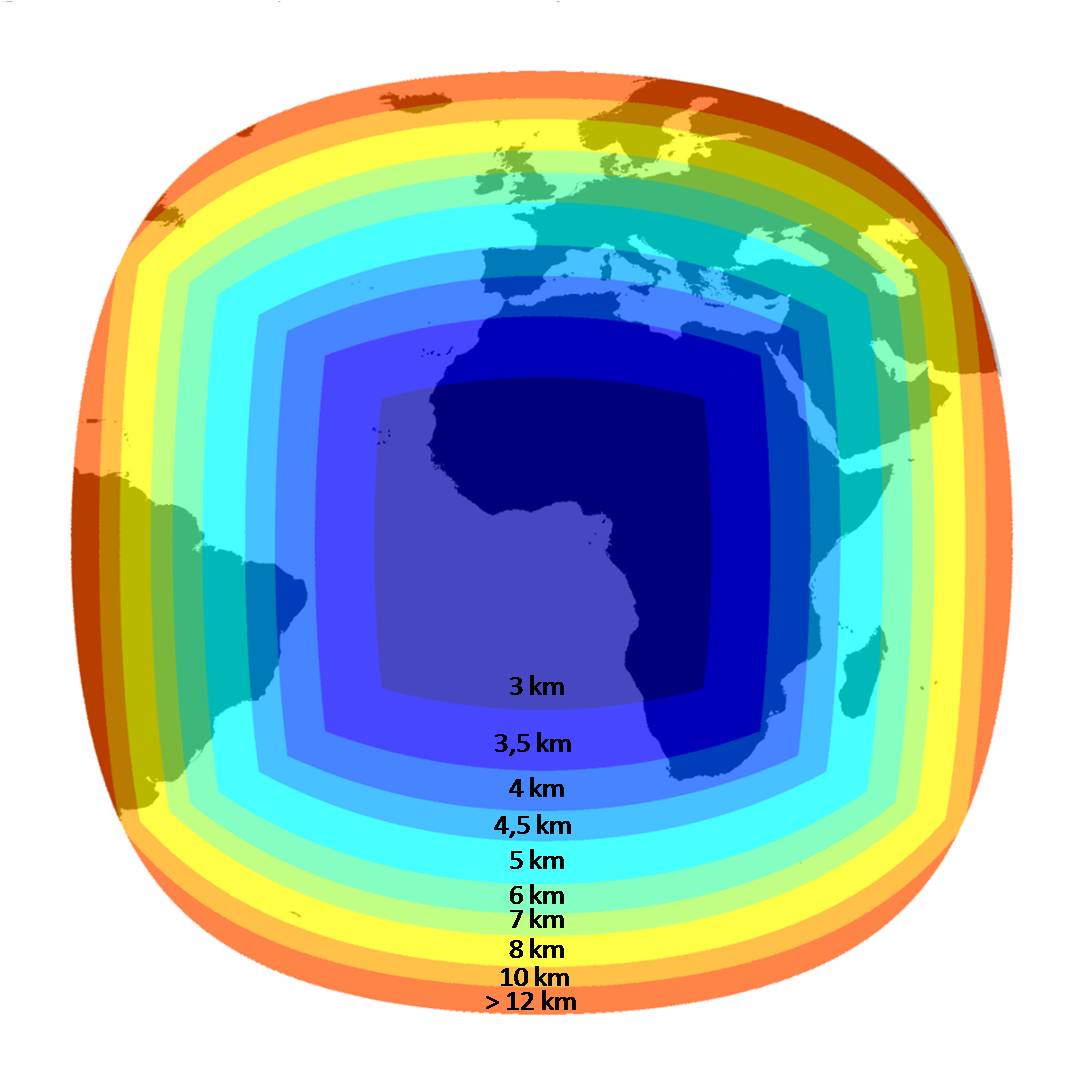
| Spatial coverage |
| ||
| Temporal coverage | Feb. 2004 onwards (updated in real time, every 15 min) | ||
| Spatial resolution | 3 km at Nadir, approx. 5 km in Europe (see illustration above) | ||
| Temporal resolution | 15 min | ||
| Leadtime | A few minutes after image reception | ||
| Method | Heliosat-2 | ||
| Version | version 4 and version 5 | ||
| Main publication | Rigollier et al. 2004 (others: see publications with keyword "HelioClim-3" or "Heliosat-2") | ||
| PVsyst compatible | Yes | ||
Go deeper
Input Meteosat images
To compute the HelioClim-3 solar radiation database in real time, our two sites (MINES ParisTech - Transvalor) have been supplied with: reception dishes, acquisition chain, computational resources and servers able to generate HelioClim-3 and to fulfill the requests from the users. The two chains are synchronized for an enhanced robustness of the SoDa Service.
The model Heliosat-2 processes the images of the Meteosat Second Generation satellite collected between 3:00 UT to 20:45 UT (72 images) to compute the 15 minute Global Irradiance values over a horizontal plane (GHI).
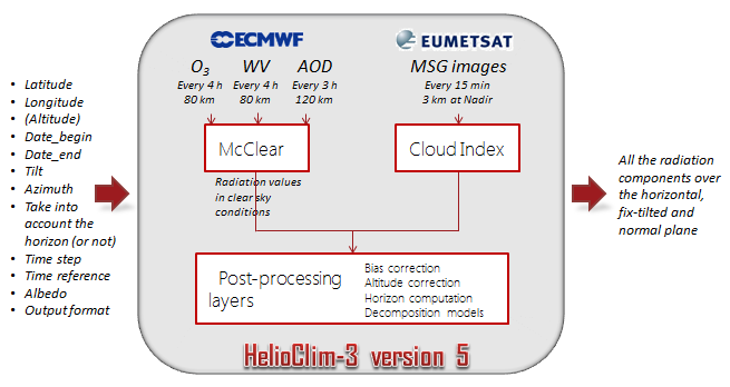
What is actually stored in HC3?
The HelioClim-3 database stores the 15 minute GHI values. When the user launch a request, post-processing layers are applied to correct these values, as illustrated by the following picture on HelioClim-3 version 5. Then decomposition models computes the radiation components on the plane orientation as requested.
Illustration: inputs, outputs, and models in HC3v5
The results of the quality assessment of HC3 versus several in-situ measurements have been published in several peer-reviewed articles.
Missing values in HC3: Several slots (or images) are regularly missed, due to internal shortage or interruption of service by Eumetsat. Except is the whole images of a day are missing, this is totally invisible for the users since the images of a day are interpolated if at least one image is available. For you information, the missing slots are available on this page with the corresponding information, if available (missing value in HelioClim: -999). Please note that the field of view is restricted to the pixels belonging to the Earth and for which the elevation angle of the sun above horizon is larger than 12 degrees.
Hypothesis "end of time integration": the date or instant given for each value corresponds to the end of the summarization/time integration. I.e. 24/04/2010 08:00 means that the associated irradiation or irradiance value has been measured between 07:00 and 08:00. This convention addresses the standard recommanded by the WMO (World Meteorological Organisation).
Outputs and derived services
From this database, several types of services are proposed: time series of radiation values (via an annual subscription or on-request), maps of radiation (on-request), typical meteorological years (on-request), calibration of HC3 data using ground measurements (on-request)...
The demo version of the HC3 Web service covers Feb. 2004 till end 2006. The HC3 Web service which delivers data for more recent years is accessible via different types of annual subscriptions. The price of the annual subscription depends on several parameters (time step of the data, type of access, plane orientation...), don't hesitate to contact the SoDa support to receive a quotation.
The presentation of the different services is available on the HC3 Web services info page. Output column content for each service is described on this page.
HelioClim-3 and Digital Elevation Model
Topography impacts the solar radiation values at ground levels in two ways: the variation of the optical path length and the shadowing effect due to the horizon. Indeed, according to the atmospheric layer tickness crossed by sun rays when reaching the ground, the radiation is modulated: the higher the elevation of a point, the narrower the atmospheric optical layer, and finally the higher the radiation. Each HelioClim-3 value is stored using the default elevation database TerrainBase 5' (worlwide database, spatial resolution of 5' of arc, equivalent to approx. 10 km).
An altitude correction is applied "on the fly" to take into account the exact height of the point requested by the user, using the SRTM database (Shuttle Radar Topography Mission, available worldwide, 90 m of spatial resolution and 10 m of uncertainty). The user just has to set the altitude to the default "Automatic" option. It is also possible to take into account the shadowing effect due to the far horizon by putting the "Compute Relief Shadows" input option to "TRUE".
Bibliography HelioClim-3, Heliosat-2, ESRA, Tubidity Linke factor
(In alphabetic order and and reverse chronological order)
| Albarelo et al. 2015 | Albarelo T., I. Marie Joseph, A. Primerose, F. Seyler, L. Linguet, L. Wald, 2015. "Optimizing the Heliosat-II method for surface solar irradiation estimation with GOES images. Canadian Journal of Remote Sensing", 41, 86-100, 2015, doi: 10.1080/07038992.2015.1040876. | Heliosat-2 |
| Bauer 1996 | Bauer O., 1996. Les échanges océan-atmosphère dans l'Atlantique subtropical nord-est : apports de Meteosat. Thèse de Doctorat, Université de Nice - Sophia Antipolis, 162 p. | Heliosat |
| Beyer et al. 1997 | Beyer H.-G., Czeplak G., Terzenbach U., Wald L., 1997. "Assessment of the method used to construct clearness index maps for the new European solar radiation atlas (ESRA)". Solar Energy, 61, 6, 389-397. doi:10.1016/S0038-092X(97)00084-4 | ESRA (clear-sky model and Linke) |
| Beyer et al. 1996 | Beyer H.-G., Costanzo C., Heinemann D., 1996. "Modifications of the Heliosat procedure for irradiance estimates from satellite images". Solar Energy, 56, 3, p. 207-212. | Heliosat-2 |
| Blanc et al. 2011 | Blanc Ph., Gschwind B., Lefèvre M., Wald L., 2011. "The HelioClim project: Surface solar irradiance data for climate applications" Remote Sensing, 2011, 3, 343-361. doi:10.3390/rs3020343 | HelioClim in general |
| Cano et al. 1986 | Cano D., Monget J.-M., Albuisson M., Guillard H., Regas N., Wald L., 1986. "A method for the determination of the global solar radiation from meteorological satellites data" Solar Energy, 37, 1, 31-39. | Heliosat |
Content: In this publication, Cano et al. recommended to apply the Heliosat-2 method only for the slots when the sun is above 18° of elevation. We decided to slightly descrease this threshold to 12° in our implementation of Heliosat-2 (HelioClim-3).
| Cano 1982 | Cano D., 1982. "Etude de l'ennuagement par analyse de séquences d'images de satellite. Application à l'évaluation du rayonnement solaire global au sol" Thèse de Doctorat, Ecole nationale supérieure des télécommunications, Paris, France. | Heliosat |
| Cros et al. 2006 | Cros S., Albuisson M., Wald L., 2006. "Simulating Meteosat-7 broadband radiances at high temporal resolution using two visible channels of Meteosat-8". Solar Energy, 80, 3, 361-367, doi: 10.1016/j.solener.2005.01.012. | Heliosat-2 |
| Cros et al. 2004 | Cros S., Lefèvre M., Albuisson M., Wald L., 2004. "From meteorological satellite data to solar radiation climatological products: the HelioClim database". European Geophysical Union, 1st general assembly, Geophysical Research Abstracts, vol. 6, April 2004, EGU04-A-03853. | HelioClim |
| Cros 2004 | Cros S., 2004. "Création d'une climatologie du rayonnement solaire incident en ondes courtes à l'aide d'images satellitales (Design of an incident shortwave solar radiation climatology using satellite images)". Thèse de Doctorat en Energetique, Ecole des Mines de Paris, 13 septembre 2004, 157 pages. | HelioClim |
| Cros et al. 2004 | Cros S., Albuisson M., Lefèvre M., Rigollier C., Wald L., 2004. "HelioClim: a long-term database on solar radiation for Europe and Africa". In Proceedings of Eurosun 2004, published by PSE GmbH, Freiburg, Germany, pp. (3)916-920, ISBN 3-9809656-4-3. | HelioClim |
| Cros et al. 2004 | Cros S., Chriqi R., Albuisson M., Wald L., Dahman Saidi A., Bennouna M., 2004. "Integration of Meteosat-derived data and digital terrain model into a GIS for local atlases of solar radiation". European Geophysical Union, 1st general assembly, Geophysical Research Abstracts, vol. 6, April 2004, EGU04-A-06543. | HelioClim |
| Demarcq 1985 | Demarcq H., 1985. "Applications de la télédétection infrarouge et visible en océanographie. Etude de la zone de dilution rhodanienne, observation des zones de production dans le golfe du Lion, et estimation de l'éclairement solaire global en Méditerranée occidentale". Thèse 3ème Cycle, Univ. Aix-Marseille II. | Heliosat |
| Diabaté et al. 2004 | Diabate L., Blanc Ph., Wald L., 2004. "Solar radiation climate in Africa". Solar Energy, 76, 733-744. | ESRA |
| Diabaté et al. 2003 | Diabaté L., Remund J., Wald L., 2003. "Linke turbidity factors for several sites in Africa". Solar Energy, 75, 2, 111-119. | Linke turbidity factor |
| Diabaté et al. 1995 | Diabaté L., Wald L., 1995. "An attempt to estimate the diffuse component of solar radiation on horizontal plane from satellite images", African Journal of Science and Technology, 11, 1, 39-44. | Heliosat |
| Diabaté et al. 1989 | Diabaté L., Moussu G., Wald L., 1989. "Description of an operational tool for determining global solar radiation at ground using geostationary satellite images". Solar Energy, 42, 3, 201-207. | Heliosat |
| Diabaté 1989 | Diabaté L., 1989. "Détermination du rayonnement solaire à l'aide d'images satellitaires". Thèse de Doctorat en Sciences, Ecole des Mines de Paris, 272 p. | Heliosat |
| Diabaté et al. 1988 | Diabaté L., Demarcq H., Michaud-Regas N., Wald L., 1988. "Estimating incident solar radiation at the surface from images of the Earth transmitted by geostationary satellites : the Heliosat Project". International Journal of Solar Energy, 5, 261-278. | Heliosat |
| Espinar et al. 2012 | Espinar B., P. Blanc, L. Wald, B. Gschwind, L. Ménard, E. Wey, C. Thomas, L. Saboret, 2012. "HelioClim-3: a near-real time and long-term surface solar irradiance database". Workshop on Remote Sensing Measurements for Renewable Energy, May 2012, Risoe, Denmark. | HelioClim-3 v3 |
| Espinar et al. 2009 | Espinar, B., Ramírez, L., Polo, J., Zarzalejo, L.F., Wald, L., 2009. "Analysis of the influences of uncertainties in input variables on the outcomes of the Heliosat-2 method". Solar Energy, 83, 1731-1741, 2009, doi:10.1016/j.solener.2009.06.010. | Heliosat-2 |
| Geiger et al. 2002 | Geiger M., L. Diabaté, L. Ménard, L. Wald, 2002. "A Web service for controlling the quality of global solar irradiation" Solar Energy, Elsevier, vol. 73 (6), pp.475-480 | ESRA (Clear sky model and Linke), Quality check |
| Grüter et al. 1986 | Grüter W., Guillard H., Möser W., Monget J.-M., Palz W., Raschke E., Reinhardt R.E., Schwarzmann P., Wald L., 1986. "Determination of solar radiation at ground level from images of the earth transmitted by meteorological satellites, Solar Energy R&D in the European Community, Series F, vol. 4: Solar radiation data from satellite images", D. Reidel Publishing Co. for the Commission of the European Communities, 100 pp. | Heliosat (original) |
| Kasten 1996 | Kasten F., 1996. The Linke turbidity factor based on improved values of the integral Rayleigh optical thickness. Solar Energy, 56 (3), 239-244. | Linke Turbidity Factor |
| Lefèvre et al. 2004 | Lefèvre M., Cros S., Albuisson M., Wald L., 2004. "Developing a database using Meteosat data for the delivery of solar radiation assessments at ground level". In Proceedings of the 23rd EARSeL Annual Symposium "Remote Sensing in Transition", 2-4 June 2003, Ghent, Belgium, Rudi Goossens editor, Milpress, Rotterdam, Netherlands, pp. 485-489. | HelioClim |
| Lefèvre et al. 2002 | Lefèvre M., Rigollier C., Cros S., Wald L., 2002. "Toward a solar climatological database: the HelioClim project". In Proceedings of 22nd EARSeL Annual Symposium "Geoinformation for European-wide integration", 4-6 June 2002, Prague, Czech Republic. Tomas Benes editor, Millpress, Rotterdam, Netherlands, pp. 223-228. | HelioClim |
| Lefèvre et al. 2002 | Lefèvre M., Rigollier C., Cros S., Albuisson M., Wald L., 2002. "A shortwave radiation database to support GODAE-related activities". Proceedings of the International Symposium "En route to GODAE", 13-15 June 2002, Biarritz, France. Published by CNES, Toulouse, France, 2002, pp. 157-158. | HelioClim |
| Marie-Joseph et al. 2013 | Isabelle Marie-Joseph, Laurent Linguet, Marie-Line Gobinddass, Lucien Wald. "On the applicability of the Heliosat-2 method to assess surface solar irradiance in the Intertropical Convergence Zone, French Guiana". International Journal of Remote Sensing, Taylor & Francis, 2013, 34 (8), pp.3012-3027. <10.1080/01431161.2012.756598> | Heliosat-2 |
| Michaud-Regas 1986 | Michaud-Regas N., 1986. "Mise en oeuvre et validation d'une méthode opérationnelle et automatique pour l'évaluation d'atlas solaires en Europe à l'aide de mesures satellitaires Meteosat" Thèse de Doctorat, Univ. Paris VII, Paris, France. | Heliosat |
| Moussu 1988 | Moussu G., 1988. "Définition d'une méthodologie de détection de phénomènes dynamiques dans une chronique d'images, et son application à quelques études". Thèse de Doctorat en Sciences, Univ. Nice. | Heliosat |
| Obrecht 1990 | Obrecht D., 1990. "Météorologie solaire et images satellitaires : cartographie du rayonnement solaire, détermination de l'albédo des sols et évaluation de l'ennuagement", Thèse de Doctorat en Sciences, Univ. Nice. | Heliosat |
| Page et al. 2001 | Page J., Albuisson M., Wald L., 2001. "The European Solar Radiation Atlas: a valuable digital tool". Solar Energy, 71, 81-83, doi:10.1016/S0038-092X(00)00157-2 | ESRA (clear-sky model and Linke) |
| Qu et al. 2014 | Improving HelioClim-3 estimates of surface solar irradiance using the McClear clear-sky model and recent advances in atmosphere composition", Atmos. Meas. Tech., 7, 3927-3933, doi:10.5194/amt-7-3927-2014 (Creative Commons Attribution 3.0 License) | HelioClim-3 v3 + McClear |
| Qu 2013 |
Qu, Z.: Modeling radiative transfer in cloudy atmosphere to assess surface solar irradiance (in French), Ph.D thesis, MINES ParisTech, 202 p., 2013. |
Heliosat, HelioClim |
| Remund et al. 2003 | Remund J., Wald L., Lefèvre M., Ranchin T., Page J, 2003. "Worldwide Linke turbidity information", Proceedings of ISES Solar World Congress, 16-19 June 2003, Göteborg, Sweden. CD-ROM published by International Solar Energy Society. | Linke turbidity factor |
| Remund et al. 2003 | Remund J., Wald L., Page, J., 2003. "Chain of algorithms to calculate advanced radiation parameters". Proceedings of ISES Solar World Congress, 16-19 June 2003, Göteborg, Sweden. | HelioClim |
| Rigollier et al. 2004 | Rigollier C., M. Lefèvre, L. Wald, 2004. "The method Heliosat-2 for deriving shortwave solar radiation from satellite images", Solar Energy 77(2), pp. 159-169, 2004, doi 10.1016/j.solener.2004.04.017 |
Heliosat-2 |
| Rigollier et al. 2001 | The new method HELIOSAT-II. Report 1 to the European Commission, April 2001. (plus some figures in Word file). Report 2, June 2001. | Heliosat-2 |
| Rigollier et al. 2000 | Rigollier C, Bauer O, Wald L, 2000. "On the clear sky model of the 4th European Solar Radiation Atlas with respect to the Heliosat method", Solar Energy, 68, 1, 33-48. doi: 10.1016/S0038-092X(99)00055-9 | ESRA (clear-sky model and Linke) |
| Rigollier 2000 | Rigollier C, 2000. "Vers un accès à une climatologie du rayonnement solaire : estimation de l'irradiation globale à partir d'images satellitales", thèse de Doctorat en Sciences et Technologies de l'Information et de la Communication, Université Nice - Sophia Antipolis, 194 p. Heliosat-2 | Heliosat-2 |
| Wald et al. 2011 | Wald L., P. Blanc, B. Espinar, B. Gschwind, M. Lefevre, et al. 2011. "Early achievements towards an automatic assessment of the uncertainty in solar irradiation using web services", Pillmann W., Schade S., Smits P. 25th EnviroInfo Conference Environmental Informatics, Oct. 2011, Ispra, Italy. Shaker Verlag, Aachen, Germany, Vol. 1, pp.309-318 | HelioClim-3 |
Comment: Model for the estimation of lower and upper bounds when selecting standard HC3 outputs and horizontal plane orientation (escribed in section 4).
| Wald et al. 1992 | Wald L., Wald J.-L., Moussu G., 1992. "A technical note on a low-cost high-quality system for the acquisition and digital processing of images of WEFAX type provided by meteorological geostationary satellites", International Journal of Remote Sensing, 13, 5, 911-916. | Heliosat |